Moselle Cycle Route – the Mosel-Radweg Stage by Stage
This article contains affiliate links to GetYourGuide. If you book through them we may earn a small commission, at no extra cost to you.
The Moselle cycle route – the Mosel-Radweg – runs for 248 km (154 miles) between Perl and Koblenz, almost entirely on tarmac and practically flat, making it one of Germany’s best-loved riverside cycle routes. Here’s our Moselle cycle route guide: all ten official stages with distances, the side routes into the Eifel and Hunsrück, the rules for bikes on trains and boats, and where to find the GPX files.
Three experiences we recommend
A guided (e-)bike tour through the vineyards, a wine tasting while your bike has a rest – and a boat trip through the most beautiful part of the route.
 Bernkastel-Kues: guided e-bike tour through the vineyards
Head up into the vineyards above Bernkastel with a local guide – the e-bike makes light work of the slopes the Mosel-Radweg avoids.
Check prices & dates →
Often sells out
 Kröv: covered wagon ride through the vineyards with wine tasting
Kröv sits right on stage 6. Park the bike, climb aboard the wagon and taste the local wines while someone else handles the hills.
Check prices & dates →
 River cruise with lock: Cochem–Beilstein return
The same stretch as the end of stage 8, seen from the water – a perfect rest day in Cochem in the middle of your cycling holiday.
Check prices & dates →
The Moselle cycle route on the map: from Perl to the Deutsches Eck

The German section of the Mosel-Radweg starts in Perl, where Germany, France and Luxembourg meet, and ends at the Deutsches Eck in Koblenz, where the Moselle flows into the Rhine. According to the regional tourist board, Mosellandtouristik, it’s 248 km long. The route follows the river through every loop and switches banks several times; the main route is signposted, and along much of it you can ride on either side, with bridges and ferries linking the two.
Want to start further upstream? The international Moselle cycle route begins in Metz. In France the river is followed by La Voie Bleue (V50), a mostly traffic-free cycle route of around 700 km that runs from Apach on the Luxembourg border via Thionville, Metz and Nancy towards Lyon; between Metz and Thionville you may also see it signed as the Véloroute Charles le Téméraire. The Mosel-Radweg itself is also part of Germany’s national cycle route D-Route 5 (Saar–Moselle–Main).
In terms of climbing it’s an easy ride: the state cycling portal, Radwanderland, gives just under 200 metres of ascent for the whole Rhineland-Palatinate section. What tires you out is the distance – and the temptation to stop in every wine village. A few sections run alongside a road or the railway, but almost always on a separate cycle path.
The 10 stages of the Mosel-Radweg – cycle map with distances
Mosellandtouristik divides the route into ten stages of roughly 18–31 km (11–19 miles). That leaves plenty of time for wine tastings and sightseeing; experienced cyclists often combine two stages a day.
| Stage | Route | km | Highlights |
|---|---|---|---|
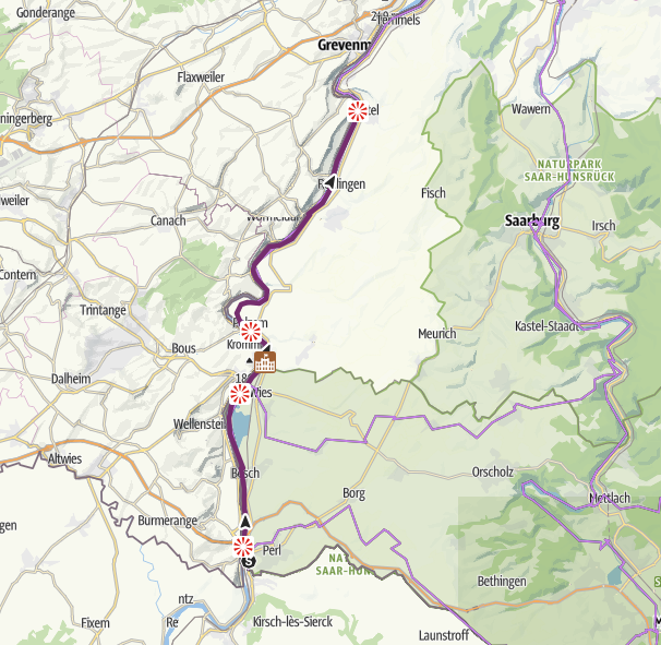
| 1 | Perl – Nittel | 25.3 | Upper Moselle, Luxembourg on the opposite bank, Roman villa at Nennig |
| 2 | Nittel – Trier | 24.7 | Mouth of the Saar at Konz, Trier |
| 3 | Trier – Mehring | 25.4 | Pfalzel, Schweich |
| 4 | Mehring – Piesport | 25.5 | Neumagen-Dhron and its Roman wine ship |
| 5 | Piesport – Bernkastel-Kues | 18.3 | Shortest stage, Bernkastel’s old town |
| 6 | Bernkastel-Kues – Traben-Trarbach | 22.3 | Hochmoselbrücke, Kröv, Art Nouveau in Traben-Trarbach |
| 7 | Traben-Trarbach – Bullay | 24.3 | Reil, the loop at Zell |
| 8 | Bullay – Cochem | 31.4 | Calmont, Beilstein, Cochem |
| 9 | Cochem – Löf | 26.8 | Treis-Karden, Moselkern |
| 10 | Löf – Koblenz | 25.7 | Kobern-Gondorf, Winningen, Deutsches Eck |
The stages add up to slightly more than the official 248 km, because each one is measured from town centre to town centre. The distances come from Mosellandtouristik’s stage pages, where you can also download GPX tracks.
Upper Moselle: Perl – Nittel – Trier
Stage 1 begins at Perl station and follows a tarmac riverside road through the “Pferdemosel” nature reserve between Besch and Nennig, then on past Palzem and Wehr to Nittel, known for the Elbling grape. A detour to the Roman villa at Nennig, home to the largest mosaic floor north of the Alps (160 m²), is only about 4 km there and back. Mosellandtouristik particularly recommends stage 1 for families with children.
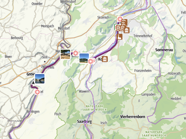
Stage 2 passes Oberbillig and reaches Konz, where the Saar flows into the Moselle and the river becomes noticeably wider. Ten kilometres later you’re in Trier – Germany’s oldest town, with the Porta Nigra and several other UNESCO-listed Roman monuments. Trier Hbf station is about 1.5 km from the route.
Middle Moselle: Trier – Bernkastel-Kues – Traben-Trarbach
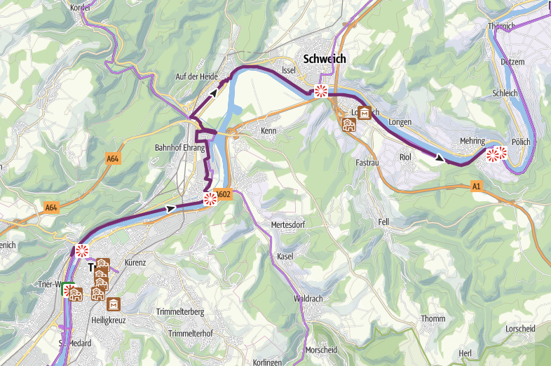
After Trier the valley narrows and the loops begin. Stage 3 runs via Pfalzel to Schweich, with its baroque ferry tower, and on to Mehring. Stage 4 to Piesport passes Neumagen-Dhron, which calls itself Germany’s oldest wine village and keeps a sailing replica of a Roman wine ship at its quay.
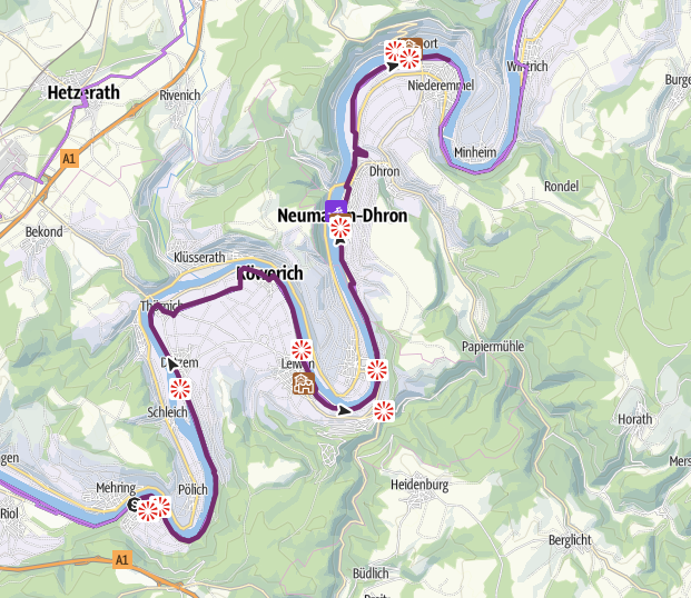
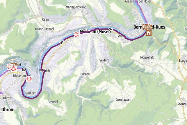
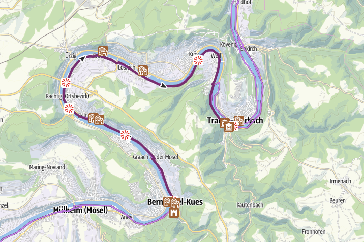
Stage 5 is the shortest on the route at 18.3 km and finishes in Bernkastel-Kues, with its half-timbered houses and the ruins of Landshut castle above the town. Stage 6 to Traben-Trarbach passes beneath the towering Hochmoselbrücke at Zeltingen-Rachtig and through the wine village of Kröv before the Art Nouveau town of Traben-Trarbach welcomes you.
Terrace Moselle: Traben-Trarbach – Cochem – Koblenz
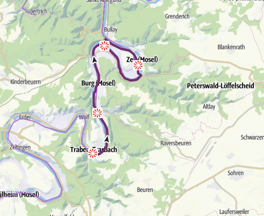
Stage 7 runs via Reil to Bullay. Between Reil and Zell the route is signposted on both banks; the long loop past Zell gives views of the Prinzenkopf and the Marienburg. Bullay is a handy junction: this is where the main Moselle railway meets the little Moselweinbahn branch line to Traben-Trarbach.
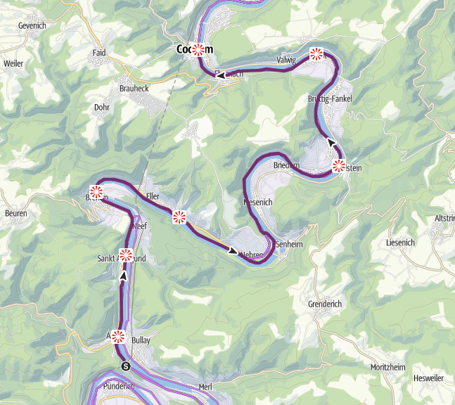
Stage 8 is the longest at 31.4 km and, for many, the most beautiful. It passes Bremm at the foot of the Calmont, regarded as Europe’s steepest vineyard, and continues via Ediger-Eller and Nehren to Ellenz-Poltersdorf. From there you can take the ferry across to Beilstein and its narrow lanes before the route carries on via Ernst to Cochem and the Reichsburg.
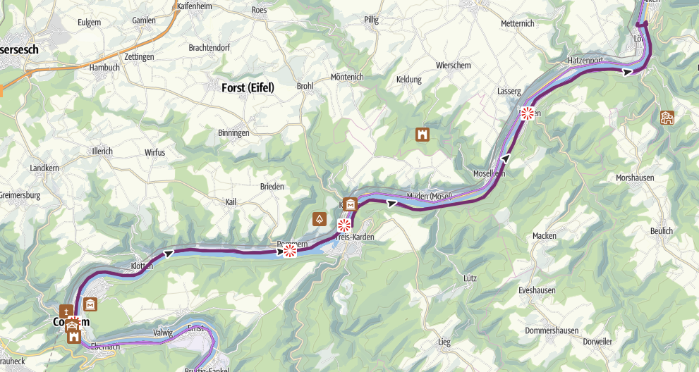
Stage 9 follows the river past Klotten and Pommern to Treis-Karden, with its Romanesque church known as the “Moselle cathedral” (Moseldom), and on past Moselkern – the starting point for the walk up to Burg Eltz – to Löf. Here the route partly runs beside the road, on its own cycle path.
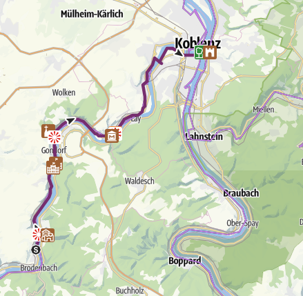
The final stage sets off from Löf via Kattenes. Just after Kattenes the main route turns off under the railway and climbs into the vineyards above the tracks towards Lehmen – keep an eye on the signs here. Then come Kobern-Gondorf, Winningen and Güls before you roll over the Kurt-Schumacher bridge and along the riverside promenade to the Deutsches Eck.
Suggested Moselle cycling itineraries
- The classic: Trier – Koblenz (approx. 200 km / 125 miles): stages 3–10, comfortably done in 5–6 days. Start in Trier and ride downstream; that’s also the direction luggage transfers normally run. Trier is an easy hop by train from Luxembourg, so it pairs well with a flight into Luxembourg Airport.
- Long weekend: Bernkastel-Kues – Cochem (approx. 78 km / 48 miles): stages 6–8 over two or three days through the most dramatic scenery on the route. Getting back: train from Cochem to Bullay, the Moselweinbahn to Traben-Trarbach and the last stretch on RadBus 360 or a regular bus.
- Day ride: Traben-Trarbach – Bullay (24.3 km): and back on the Moselweinbahn – simple logistics with no car needed.
- Family ride: stage 1 (Perl–Nittel) or stage 4 (Mehring–Piesport), both recommended for families by Mosellandtouristik.
Side routes: Maare-Mosel, Ruwer-Hochwald and the Saar cycle path
Several of the best cycle paths in the area follow disused railway lines down to the Moselle. That means gentle, even gradients – and it pays to ride them downhill: take the RadBus up and freewheel home.
- Maare-Mosel-Radweg (Daun – Lieser/Bernkastel-Kues, approx. 53 km + 3 km): an old railway trackbed from the volcanic landscape of the Eifel via Wittlich down to the Moselle at Lieser, then 3 km on to Bernkastel-Kues. Expect a viaduct above Daun, the 560 m “Großes Schlitzohr” tunnel and, after Eckfeld, almost nothing but downhill. RadBus 300 and express line 555 run between Bernkastel-Kues and Daun.
- Ruwer-Hochwald-Radweg (Hermeskeil – Ruwer/Trier, approx. 48 km): a family-friendly railway path from the Hunsrück through the winding Ruwer valley to the Moselle near Trier. From the watershed beyond Reinsfeld it’s a steady descent over many bridges. RadBus 222 runs back to Hermeskeil at weekends and during the holidays.
- Saar-Radweg (Sarreguemines – Konz, approx. 110 km): a riverside route from France through Saarland to the mouth of the Saar at Konz. The last 30 km or so, in Rhineland-Palatinate and past Saarburg, are flat and follow the riverbank.
Other connecting routes include the Kyll-Radweg near Trier, the Salm-Radweg from Klüsserath, the Nahe-Hunsrück-Mosel-Radweg from Neumagen-Dhron and the Schinderhannes-Untermosel-Radweg from Burgen.
Bikes on trains, buses and boats
Train
The train is a cyclist’s best friend in the Moselle Valley, but it doesn’t follow the river all the way. The Moselle line runs Koblenz – Cochem – Bullay and then via Wittlich to Trier, the Moselweinbahn links Bullay with Traben-Trarbach, and the Upper Moselle line runs from Trier to Perl. So there’s no railway on the Middle Moselle between Trier and Traben-Trarbach.
- On regional trains between Koblenz and Perl your bike travels free Monday to Friday from 9am and all day at weekends and on public holidays.
- Before 9am on weekdays you need a bike ticket.
- Space isn’t guaranteed – bikes are carried when there’s room. Cargo bikes are excluded in the VRM network, and bikes can’t be taken on rail replacement buses (SEV).
On a sunny Saturday in September the bike space on trains between Cochem and Koblenz can fill up. Travel a little earlier or later in the day if you can, and check for closures and diversions on the Mobilitätsatlas before setting off.
RadBus – bike buses with trailers
Where the train doesn’t go, the RadBus lines fill the gap. The buses tow a bike trailer, run during the season and have their own bike tickets. Line 333 (Moseltal) runs Trier – Ruwer – Schweich – Neumagen – Bernkastel-Kues with space for up to 20 bikes, on Saturdays, Sundays and public holidays and also on weekdays during Rhineland-Palatinate school holidays. Other Moselle lines are 220, 330 and 360. Booking ahead is a good idea; timetables and season dates are on radbusse.de.
Boats and ferries
Ferries and most excursion boats take bikes for a small extra charge, space permitting. That makes it easy to cycle one way and take the boat back – or the other way round. If you’d rather travel the whole way on the water, read our guide to a Moselle river cruise.
Bike hire, e-bikes and luggage transfers
There’s no shortage of bike hire along the Moselle, with standard bikes, e-bikes and pedelecs. Several hire firms will deliver the bike to your starting point and collect it from another town, which suits a one-way trip – handy if you’re flying in and don’t want to bring your own bike. Mosellandtouristik keeps an up-to-date list of hire outlets, e-bike charging points and bike repair shops (ordered along the river) on its cycling services page.
Luggage transfers between your accommodation are available on the Mosel-Radweg, normally downstream from Perl towards Koblenz. The easiest option is to book a package with accommodation and luggage transfer included, but you can also arrange it yourself. Around 60 places to stay in the Moselle–Saar region are certified as cycle-friendly (Bett+Bike), with lockable bike storage and tools – and they welcome guests for a single night too.
The Mosel-Radweg has 40 “Lauschpunkte” – audio stops between Perl and Koblenz that you listen to via the free Lauschtour app. Good company on the quieter stretches, and a way to find out why the village you’ve just ridden through looks the way it does.
Best time to cycle the Moselle Valley
In practice the cycling season runs from April to October. The RadBus lines and many boats only operate in season. Spring and early summer bring green vineyards and fewer people; September and October mean the grape harvest, wine festivals and golden slopes – but also busier paths around Bernkastel-Kues and Cochem. High summer can get hot in the narrow valley, so make an early start. Read more about the Moselle Valley weather and the best time to visit the Moselle.
GPX files and official maps
- visitmosel.de – Mosel Cycle Path – the official page in English with all the stages; each stage page has a GPX download.
- Tourenplaner Rheinland-Pfalz – the whole route with map, elevation profile and GPX.
- visitmosel’s Komoot collection – the ten stages, ready to navigate in the app.
- Radwanderland fact sheet (PDF, German) – route, stations, RadBus and connecting routes.
To see where the cycle route sits in relation to towns, airports and roads, take a look at our Moselle Valley map. Using a motorhome or a tent as your base? You’ll find tips in our guides to the Moselle by motorhome and Moselle campsites.
Cycling the Moselle: frequently asked questions
How long is the Moselle cycle route?
The German section from Perl to Koblenz is 248 km (154 miles), divided into ten stages. If you start in Metz in France it’s considerably longer.
Is the Mosel-Radweg difficult?
No. The route is almost entirely tarmac, mostly separated from traffic and essentially flat – just under 200 m of ascent in Rhineland-Palatinate. It’s the distance, not the hills, that’s the challenge.
How many days do you need for the Mosel-Radweg?
The full route from Perl to Koblenz is comfortable in 7–10 days using the official stages. Most people can ride Trier–Koblenz (approx. 200 km) in 5–6 days with time for wine tastings and sightseeing.
Can you take bikes on the train along the Moselle?
Yes. On regional trains between Koblenz and Perl it’s free Monday to Friday from 9am and all day at weekends and on public holidays, space permitting. Before 9am on weekdays you need a bike ticket. There’s no train between Trier and Traben-Trarbach – that’s where the RadBus comes in.
Which direction is best to cycle?
Most people ride downstream, from Perl or Trier towards Koblenz. That’s also the direction luggage transfers normally run. You’ll barely notice the gradient, but the wind can be against you in either direction.
Where can I hire an e-bike on the Moselle?
There are hire outlets in most of the larger towns along the route, and several offer delivery and drop-off in another town. Mosellandtouristik keeps an up-to-date list of hire stations and charging points.
- Mosellandtouristik – Mosel Cycle Path – 248 km, 10 stages, ADFC 4 stars since 2024, waymarking, surface, D-Route 5, international route from Metz, French route names, family stages, GPX/Komoot
- France Vélo Tourisme – La Voie Bleue (V50) – approx. 700 km from Apach to Lyon via Thionville, Metz and Nancy, mostly on dedicated cycle paths, former “Charles le Téméraire” signs
- Mosellandtouristik – Mosel-Radweg stage pages (stages 1–10) – stage lengths, route, Nennig villa, Calmont, Beilstein ferry, Kattenes–Koblenz, Lauschpunkte
- Radwanderland Rheinland-Pfalz – Mosel-Radweg fact sheet – ascent, stations, RadBus lines, Reil–Zell, connecting routes
- Radwanderland Rheinland-Pfalz – Saar-Radweg fact sheet – approx. 110 km Sarreguemines–Konz, last approx. 30 km in Rhineland-Palatinate
- Mosellandtouristik – Maare-Mosel-Radweg and RadBusse – tour tip – length, railway trackbed, viaduct, tunnels
- Mosellandtouristik – Ruwer-Hochwald-Radweg – 48.2 km, railway path, RadBus 222
- Mosellandtouristik – Cycling services – bikes on trains and boats, hire, luggage transfers, Bett+Bike
- VRM – fare regulations – free bike carriage after 9am, cargo bikes excluded, no guaranteed space
- RadBusse Rheinland-Pfalz – line 333 – route, operating days, 20 bikes
Last updated: October 2026. Facts checked against the sources above; prices and opening hours may change.